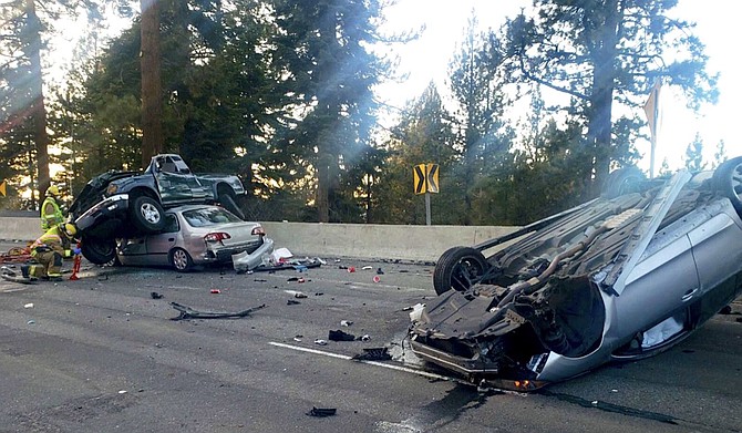
A collision on Highway 50 claimed the life of a Gardnerville man on March 7.
Nevada Highway Patrol
Eleven people have been killed since 2014 on what may be the deadliest stretch of highway in Douglas County.
Highway 50 at Lake Tahoe has been the location of a fatal collision every year except 2018, with three in 2015.
Three of the most recent fatalities involved impaired drivers crossing the centerline of the highway causing head-on collisions.
During a recent four-year period, crash rates were more than 50 percent higher on Highway 50 between Elks Point Road and Glenbrook Drive when compared with other similar highways across the state, according to the Nevada Department of Transportation.
Average daily peak-season traffic on the highway has grown from 15,000 vehicles daily in 2014 to nearly 20,000 in 2019, according to the state.
In an effort to improve safety on the highway, the state has launched a web site and will host information booths to gather public feedback on planning for future traffic improvements to Highway 50 at Lake Tahoe’s East Shore through Douglas County.
Amid increasing traffic, the state also plans additional highway improvements in coming years.
Next year, the state will install a traffic signal at the intersection of Highway 50 and Warrior Way.
By controlling all directions of travel, the signal will help provide designated and safer access to and from the highway. The state is also evaluating opportunities to relocate on-street parking to off-highway parking areas, thus reducing safety concerns associated with vehicles parking along the shoulders of the heavily traveled section of highway.
Within the coming five years, the Department also plans to repave and rehabilitate approximately 13 miles of Highway 50 between Stateline and Spooner Summit for a smoother and safer drive.
Those interested may visit dot.nv.gov/US50EastShore for study information and, through July 16, submit feedback and suggestions for the highway via an on-line survey.
Residents may also visit the following locations for study information and to provide feedback during the week of June 21:
Noon to 2 p.m. June 22, Rabe Meadows Trailhead, Stateline
Noon to 2 p.m. June 24 Cave Rock State Park
4-6p.m. June 24 Zephyr Cove Park, Zephyr Cove
Noon to 2 p.m. June 26, Kahle Community Center, Stateline
Those requiring special accommodations to access study information can contact 702-232-5288.
Through the Highway 50 Corridor Management Plan, the state will gather public feedback and evaluate the highway between Spooner Summit and the Nevada-California border at Stateline.
The planning process will develop goals and identify vehicle, transit and multi-modal strategies, including seasonal parking strategies, to enhance roadway travel and safety for all.
The resulting plan, completed in spring 2022, will provide a high-level vision for potential options to improve traffic safety and mobility for all transportation types. The plan will be developed cooperatively with the TRPA, Tahoe Transportation District, United States Forest Service, Douglas County and other stakeholders, and will be consistent with state and regional transportation and environmental goals established in the Lake Tahoe Bi-State Compact.
More information is available at dot.nv.gov or by calling (775) 888-7000.

Comments
Sign in to comment